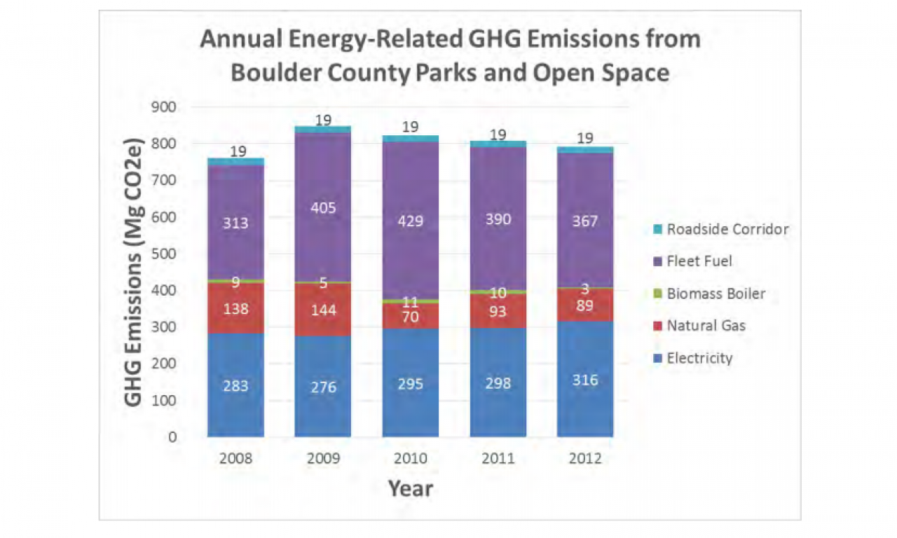
The Boulder County Parks and Open Space Department offers grants for research on county open space lands each year. The following is a summary of a 2014 study conducted by Mark Easter, Amy Swan, and Stephen Williams with the Natural Resource Ecology Laboratory at Colorado State University in Fort Collins, Colorado. Their research project focused on greenhouse gas (GHG) inventory from agriculture, forestry and other land uses.
Executive Summary
This study was done for the Boulder County Parks and Open Space (BCPOS). There were six key tasks to accomplish:
- Quantify a baseline of GHG based on existing vegetation, use, and condition on BCPOS lands.
- Identify and quantify the inputs and outputs of GHG on BCPOS lands based on existing agricultural production on cropland, pasture and rangeland including livestock.
- Identify and quantify the inputs and outputs of GHG on BCPOS grassland restoration.
- Identify and quantify the inputs and outputs of GHG on BCPOS forestry land based on forest type and management (e.g. thinning and prescribed fire).
- Provide a forecast of carbon emissions for a 10 year period.
- Make recommendations about best management practices to reduce GHG emissions and increase carbon sinks on BCPOS lands.
We worked closely with BCPOS staff to collect GIS layers and identify land management details which affect soil and biomass carbon and greenhouse gas emissions on BCPOS lands. We utilized a combination of IPCC Tier 1, 2 and 3 methods as follows:
- For agricultural cropland, pasture and grazing land, we used the DayCent model to predict soil carbon stocks and greenhouse gas cycling in response to land management.
- For soil carbon stocks on non-agricultural lands, we used the USDA NRCS SSURGO soil database.
- For biomass carbon stocks on BCPOS non-agricultural forest, shrub, and range lands, we used a combination of local, regional and IPCC default biomass carbon stock measurements in combination with BCPOS vegetation maps.
- On BCPOS agricultural conservation easements, we used a combination of statistical models to predict soil and biomass carbon stocks.
- For livestock, we used IPCC Tier 2 empirical models to predict annual greenhouse gas emissions.
Call for 2016 Studies
The department is currently accepting proposals for 2016 funding. Grants are awarded up to $10,000 per project. There is no minimum amount that will be awarded for a project. Deadline for proposals is January 18, 2016.
Department staff have identified priority needs for research including these seven topics:
- Use preferences of people with disabilities on Boulder County Parks and Open Space.
- Study that demonstrate the effective benefits of using biochar or other wood fiber products in restoration efforts, revegetation, ag production, etc.
- Inventory of Monarch butterfly breeding sites and milkweed mapping.
- Study measuring the effects of trails on adjacent vegetation.
- Study to determine most effective herbicides for control of invasive plants that also minimize impacts on pollinator plants.
- Effective Habitat Analysis (fragmentation mapping) of Boulder County.
- Study examining the attitudes of Boulder County residents to hunting on open space for resource management needs.


